Thursday, June 27, 2013

End of field measurement campaign: the BBQ

We are all well-known in the research area by now - suddenly in June a lot of young people arrive, driving cars and jumping out at places where a normal Portuguese youngster would never go to measure "water things". We also have our favorite bars and lunch places. Mario and Carolina's Veneluso bar is one of these places where we often meet to have lunch. These are very nice people and we would like to thank them for their hospitality. Mario e carolina, Muito Obrigado!!! This year , after taking the sapflow and meteorology equipment out, we were invited by the owners of Restaurante Sesta in Covao do Lobo for a barbeque. They have a place where you can organise big weddings and play a game of futball. Big thanks!!!

Game of futball, girl power always wins
Dinner with carne, sardinhas, saladinhas, pao and cerveja.
This was more or less the end of the field campaign. Today Michel and I collected all the hydrological equipment at the student's house in Barra and managed to squeeze everything back in the Ford Transit for our two-day trip to Amsterdam. Next week the reporting phase will start and the course ends in three weeks. I am sure we all enjoyed it and learned a lot!

Tuesday, June 25, 2013

Geophysics at Mesas: Dualem again...

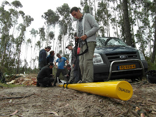
The Tabuaço and Mesas group share an island, that is an island of Quaternary sand "floating" on top of Cretaceous clay. The question is now where the catchment boundary is, or more precisely, where does the water end up that is infiltrating in that island of sand, is it in the Tabuaço or in the Mesas River? So the group called in Michel for some shallow geophysical measurements using the new Dualem-421S sensor, basically a 4-metre yellow pipe that you have to carry along. Here you see them plowing through a forest, and later through a fallow area to get their information about the thickness of the sand and the palaeotopography of the clay surface.

Doing shallow geophysical measurements with the Dualem in the relative cool of a pine plantation...
and Dualem group plowing their way through a rough patch, temperature above 30 degrees Celsius!
We did 600 m in less than 2 hours measuring every 5 steps. We had problems to convert the data from the instrument to the inversion program, but Fernando Santos from EMTOMO in Portugal, who seems to work day and night, really helped us out and we could use his EM4Soil program to invert the data. Seems that the sand layer was sometimes thicker than the Dualem could reach (about 7 m, see graph below), so back later with the Geonics EM34 to do deeper measurements of the resistivities. With EM4SOIL we can do the combined inverison both for DUALEM and EM34!

Graphical display of the Dualem measurements, values below 1 indicate clay, those around 2 groundwater and higher values represent dry sand.
There were several wells in the area, so their water levels will also be measured accurately with a level to determine flow direction, question answered!

Friday, June 21, 2013

Pictures!

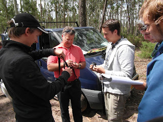
Vince, Maarten and Joris trying to figure out how the Dualem harness works.
Joris preparing a salt dilution discharge measurement in the middle of the night.

Salta catchment group picture!

The 50.000 dollar yellow light post.

Even Michel never used this!


 Greetings from Anne, Robbert, Joris and Corne


Thursday, June 20, 2013

Research in the São Romão sandbox

Let's now introduce a group that hasn't featured much yet on this weblog. They are the guys who study the São Romão Catchment hydrology - Seife, Bart, Jelmer and Laurus). Where the other catchment groups have some geological variation in their area, this group basically works in a large sandbox (young and old dunes) with only small outcrops of Cretaceous clay at the surface. Nevertheless, although this seems a simple system, you can dedicate your life to such systems, as our Prof. Pieter Stuyfzand has proven.

With the chemistry done, nitrate pollution found and dirty smelling wells (indication of anoxic conditions in the clay) visited, this group is now focussed on determining the palaeo-topography of the clay surface. Between the Cretecous and the dune deposits, there is a time hiatus of some 60 million years! So there was ample time for erosion creating valleys in the clay deposits that are now covered by dune sand. You cannot see these valleys obviously, but they can influence the flow of water in the area. With our geophysics, you can find the depth of the clay below the sand, and if you do enough measurements, you can see a 3D pattern, or the old landscape that existed before the sand was deposited on it.

Seife, Jelmer and Laurus working on the terrameter in a Eucalypt plantation in search for clay
The group started out with electromagnetic measurements, and today did some more vertical electrical soundings to find the clay. First in a pleasant eucalypt forest where they found the clay at a few meters depth, and then to the south of their area where it was at even less depth. This means short measurements and quick results.

Bart looking on while Seife and Laurus calculate apparent resistivities, also discovered that Laurus name sounds better in French...
So we were done early and had some time to do a pumping test. These guys do really ahve an artesian well in their area and we decided to subject it to the pumping test.

Artesian (free flowing) piezometer in the São Romão catchment
This place has a pumping piezometer, a monitoring piezometer in the confined (artesian) aquifer, and a piezometer in the phreatic zone. If the clay layer causing the artesian conditions is closed, we should see no change in the phreatic level while pumping below the clay layer. 

Pumping test in the São Romão aquifer
Pump was brought out, water level data logger installed and programmed to do a pumping test, pump started and pump discharge measured. And indeed, while the water level in the confined piezometer went down like a pelican going for fish, the one in the phreatic zone did not care to respond at all to the pumping. Textbook case! Now they have a good indication of the hydraulic conductivity of their sandy area. We are nearing the end of our field course, next week the final measurements...

Wednesday, June 19, 2013

Geophysics, pumping tests and rabbits


“I don't feel like eating much here, when I eat too much I start feeling sick” said Corné just before the grilled rabbit, ordered by Bob, arrived at our table. I was ready to get a bit worried, but when the waiter asked Corné if he wanted some more, there was no sign of him feeling sick when he nodded enthusiastically and said that this was nice. Rosa (vegetarian) just shook her head. This all happened after a sometimes smelly day at the garbage dump.

But let's start a bit earlier with the quest for pumping test locations by the Tabuaço and Mesas groups. But you innocent reader of this blog might ask, what in the world is a pumping test? Well, in short, it is us making two tubes in the soil (called piezometers by hydrologists) that both go into the groundwater, putting a pump in one of the tubes, switch it on and then monitor the change in water level in the other piezometer. There are a few things that matter, one is that you need to be able to pump enough water out, so the soil should be sandy and deep enough to provide this. And that is exactly where things can get messy. We started with an existing piezometer near Tabuaço village, which was in sandy soil. So the group started augering away and describing the soil that came out.

Soil description from an auger hole - intra-team work
But suddenly, oh no, Cretaceous clay entered the auger hole sample! How was this possible? Michel went to investigate just behind the hill where we were augering away and found the reason. The groundwater was above the caly and there would never be enough water there to do a pumping test. On the other hand, we found a beautiful contact spring. 

Contact spring where the Quaternary sand was lying on top of impermeable C5 Cretaceous clay
Unabashed by this unsuccessful attempt at doing a pumping test there, Jet suggested to do one at a piezometer they had just installed in the Mesas area. As far as the group remembered, the soil was sandy enough to succeed there. So of we were to mesas. One part of the group again put the auger to work, whereas the other group aimed to estimate the clay depth. This because the site was close to the village of Montouro, which is known for its lack of water because of the closeness of the clay to the surface. So the EM34 geophysical instrument was taken out of the car and put to measure.

Mesas and Tabuaco teams doing geophysics before attempting to make a pumping well.
In the mean time work on the pumping well started and the first water was taken from the hole with the bailer. Then the hole started to sound dry and the soil became very sticky. Clay was also confirmed by the EM34 and by the large diamters of the wells in the area. Bummer, again clay messed up their plans for a pumping test, so they decided to go ahead with ring infiltrometer measurements, rather than try pumping from their clayey soils. Sometimes you learn more from a failed pumping test than from a successful one!

So fast forward to today again. We had plans for the garbage dump. These were daring and included the first testing of Michel's new toy, the DUALEM-4 electromagnetic geophysical sensor, doing a Continuous Vertical Electrical Sounding to see if the dump pollution plume had cleaned up, and performing a pumping test, all in one day. Eat this! Now, there are very few MSc students in the world who may use a $48,000 Dualem - new from the box - in a field course. Most supervisors would turn pale, shiver and tremble with fear at this taught. Not us. So there Bob, Vince, Anne, Thomas, Joris and Robbert went of with the $48,000 yellow tube to study the secrets of the dump site.

Instruction by Michel into the operation of a brand-new Dualem instrument (the not so fancy-looking yellow tube).
After some practicing our students got the hang of it and measured a few transects, stopping every 5 m to do measurements.

Anne marking next measuring location, Bob working the controller and Vince and Robbert carrying the Dualem-4
While this was going on, Joris and Corné hammered on elctrodes and the CVES Terrameter was started to compare results with the DUALEM measurements. 

Finally, one thing remained, which was the pumping test. Here we were in sandy soil and had a pumping well available from last year. Pump installed, datalogger for monitoring started, Maarten swallowing a mouthfull of dirty garbage-lake pump-priming water as lunch to get the flow going and pumping started. Water in the monitoring well went down very fast and fear built up as wether our monitoring sensor would remain below water (it did). Bob digging ditches as pump water was measured to know the pump capacity.

Determining pump capacity for the aquifer transmissivity test
Now it was seven o'clock and a few of the crew started to get hungry, but at the same time their mind was not at cooking. So we decided to eat dinner at Fornos, a small restaurant in Costa Nova. And that's where Bob's rabbits came in... Tomorrow, new findings in Sao Romao!
 

Sunday, June 16, 2013

More hydrochemistry!

Frantic water sampling has occured over the last few days, even on Saturday teams of students returned to the field to collect precious water to unravel the secret chemical composition. Tomorrow in the morning, I'll visit the student's house to pick up their samples, acidify them for conservation, check their data files and then send them off by courier to our hydrochemistry laboratory at the VU University for analysis. John will do this quickly and even before they are back in the Netherlands, they may already have the analytical results of this week's samples. In the previous post, I already mentioned some ways of getting water out of the soil to get a sample. Here follows another one that's unique to our Hydrology MSc course. It is what we call "the VU Spiral Auger Sampler for Extraction of Shallow Groundwater In Sandy Soils" or in short the VUSASESGISS. It is new, it is exciting! Here you see one of the teams in action, getting it into a not so sandy soil...


This VUSASESGISS is a very sensitive device that needs gentle treatment. I did not know this either as we had only used it on the beach where it always gave ample water no matter what you did. Hey, that is strange - there's no water, said Corné when Joris pulled the syringe and no water emerged for the tenth time that day. At some stage Joris got the idea to suck on the tube rather than to use the syringe, and suddenly water did emerge. Now we were in business. Seemed that we had pulled the syringe to eagerly all the time. This opened up a whole new venue for sampling and Anne was the first to profit taking a 10 cm resolution soil water profile for analysis.

Spiral auger sampling on ancient  dunes, but now a just logged pine plantation
The next day, the Presa velha group also decided that they should use it and got some samples from a hardpan soil.

Bob and (headless) Vince pulling water from the soil using the VUSASESGISS
Perhaps very wisely, the other teams did not try out this device yet. In the process, all my sample bottles have been used by this very active lot of students. And that's great!

In the meantime, the sapflow system had been operating and Louise and Patricia decided that it was time to collect some data and change the heater battery. Wisely they brought an umbrella as computer screens and sunshine do not work together well.

Patricia and Louise downloading sapflow data in the Mesas catchment
Today, Sunday, Michel and I did some more spiral auger water sampling for our colleague Pieter Stuyfzand, who is into dune groundwater very much. So we went to the beach and a pine forest to get him some water... and now it rains again, but only drizzle. Time to go to bed...


Thursday, June 13, 2013

Sapflow and hydrochemistry

The water balance of the catchments is quantified by a member of each of the five groups working in the Tabuaco, Mesas, Presa Velha, Salta and Sao Romao catchments of the Boco River catchment. This is a jolly group that comes together occasionally to set up the meteorological tower for instance, or in this case, to install the sapflow equipment for tree transpiration measurements. Looking  for a safe site took some time and finally we decided to use the place near the saline well in Patricia's Mesas catchment.

Tree with sapflow sensor and group programming a Campbell Scientific CR1000 logger to measure transpiration.
Deciphering CRbasic program code in the field to connect the many sapflow sensor wires
Two pines and two eucalypt trees were selected for torture by drilling holes and installing the temperature and heater needles, afterward covering everything up with aluminum foil and fixing it with our famous "yellow tape".

I should say something here about this yellow tape. Michel orders this from a secret company, and it is an invaluable tool in hydrology for fixing things, and also a secret clue for finding buried piezometers back that only VU hydrology students have. The whole area is now littered with yellow tape in a functional way, as a sign to our students that "something happened" in previous years when they find yellow tape at a site.

Sharkie lost...
In the meantime, somewhere on a deserted island in the Ria de Aveiro, Valerie and Marijn were still having a go at finding fresh water. After a particularly tiring day, Valerie won a battle with a baby shark and her Dutch roots nearly forced her to eat it "herring style".

Hydrochemistry in a plantation forest

Back to the MSc students in the Boco River catchment who now have moved from installation of expensive equipment to collecting water samples.Many steps have to be taken in the right order to get a good sample. You can choose a well, but it may be dirty (dead dogs, lizards, and even a car could be inside). So better are the sometimes beautifully decorated fontes (public water holes), especially when it rains. For those who like more challenging conditions, piezometers are the real thing.

You could of course look for a piezometer installed in  earlier years, but we do hide them well and finding them back can be a challenge too, where sometimes whole stretches of forest soil are dug up. Below the joy and pride of two dedicated students and the author of this text (Waterloo) when the students found one of these lost piezometers back.

Waterloo, Joris and Robbert enjoying the view of a long lost piezometer (Thanks Anne for the photograph)
If an old piezometer has been utterly destroyed, such that you only find back some yellow tape and a damaged cap, installing a new one seems the right thing to do. The three strong guys in this group (Robbert, Corne and Joris) thought it decent to let Anne have a go at it so that they could swing her around to get the casing into the soil.


When the piezometer is finally installed, has been cleaned and otherwise approved, the teams can get water out through a simple ball-valve attached to a tube. Below you see the sampling of water at their favourite spot, the illegal garbage dump, where in addition to contaminated water, you can also find small cats to put on your balcony so that their cries can keep you up all night.


Now everything has to be meticulously clean and we are guzzling up distilled water to rinse all bottles and sampling equipment. Hydrochemistry is not a job for natural born pigs.

Vince cleaning a measuring cyclinder

Then comes the job of filtering water, sometimes done by two students and sometimes causing confusion on who should close the bottle without including an air bubble.

Rosa and Maartje, specialists at filtering and closing bottles  without air bubbles...


Joris and Corne, sometimes less adept on bottle closure decisions as they have only one hand free each
 Then comes the job of measuring pH, electrical conductivity, alkalinity, nitrate/nitrite and temperature of sometimes very smelly water.